
Route Description
Aihara Station→Nanakuni and Aihara Special Green Conservation Area→Nanakuni-toge Mountain Pass→Dainichi-do Temple→Dewa-sanzan Memorial Tower→Aihara-chuo Park→Aihara Station
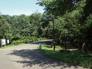
The Aihara area is extensive and nature-rich. In the area near Aihara Station, the Old Kamakura Road and the ridge road connecting to it have remained, creating an atmosphere of an old mountain trail.
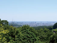
Aihara-chuo Park is a park which takes advantages of the topography of the valley. Facilities, such as the gently sloping square, a walking path in the forest and a charcoal kiln, establish an environment where visitors can coexist with nature.
* These are estimates given for a person, weight 60kg, moving at 4km per hour, walking 10 min.=30kcal, one step=70cm.
(1.17MB)
* Some details in the PDF walking map may differ from Google Map.
* Contact regarding the PDF walking map offered on this website.
[Machida City Health Center Health Promotion Dept. TEL 042-724-4236]