Route Description
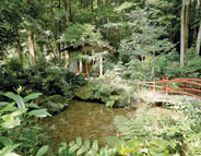
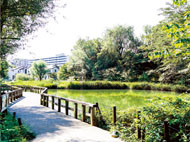
Kokubunji Station→Tokyo Metropolitan Park-Tonogayato Gardens →Momiji-bashi Bridge Path→Shinjiro-ike Pond (inside Tokyo Keizai University)→Kurabonezaka Slope→Nukui Shrine(in Koganei City)→Sorosen-en Park (in Koganei City)→Musashi-Koganei Station
You can feel the vastness of hake (the Kokubunji cliff line), which is a typical feature of Musashino, and the changing seasons.
* These are estimates given for a male, weight 60kg, moving at 4km per hour, walking 10 min.=30kcal, one step=70cm.
(5.8MB)
* Some details in the PDF walking map may differ from Google Map.
* Contact regarding the PDF walking map offered on this website.
[Kokubunjicity Health Promotion Section TEL 042-321-1801]